7 things you probably didn't know about maps
February 3, 2014 -- Updated 1011 GMT (1811 HKT)
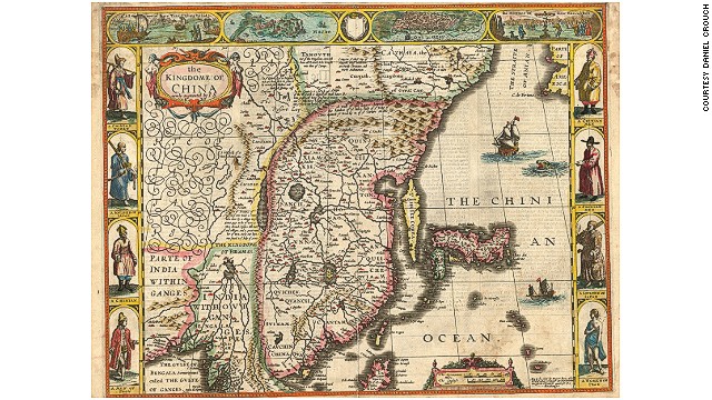 London-based map dealer Daniel
Crouch shares a few unusual or rare maps from a recent exhibition in
Hong Kong. According to Crouch, maps of BRIC nations (Brazil, Russia,
India and China) are rising in popularity among map collectors. This
17th-century map of China is a double-page hand-colored engraved map
published in 1665 by John Speed.
London-based map dealer Daniel
Crouch shares a few unusual or rare maps from a recent exhibition in
Hong Kong. According to Crouch, maps of BRIC nations (Brazil, Russia,
India and China) are rising in popularity among map collectors. This
17th-century map of China is a double-page hand-colored engraved map
published in 1665 by John Speed.
HIDE CAPTION
'The Kingdome of China,' 1665
STORY HIGHLIGHTS
- "Paper towns" were fake places added to maps by mapmakers in order to dupe forgers into copying them
- The world's best map collection is in Paris, says map dealer Daniel Crouch
- Maps of BRIC nations are popular in the collecting world right now
But what collectors often find most entrancing about maps are how they provide portals into history.
The rise and fall of
cities, the charting of war and adventure, the promise of riches through
trade ... history continues to be rewritten according to scholars'
reinterpretations of ancient cartography.
John Selden's 17th-century map of China made a huge splash recently as the stimulus for two new books
analyzing London's rise as an economic hub (the city's success is
inextricably linked to trade with China, as the Selden map illustrates).
According to some
experts, the current unprecedented volume of global travel is also
contributing to a burgeoning interest in map collecting.
"I believe that as people
travel more, migrate more and speak more languages, and as business
becomes more globalized, the appeal of two types of attachment to the
idea of 'place' increases," says Daniel Crouch, a London based
specialist of antique maps and atlases.
"One, as an
identification with, or memory of, a place or homeland left behind, and
the other as a statement of a new 'home' or adopted country, or fondness
for a land visited."
Crouch reveals some
fascinating map facts gathered from a lifetime of collecting and selling
antique maps, and shares favorites from his most recent exhibition in
Hong Kong featuring maps of China.
7 things to know about maps
1. It's still possible to have your own world-class map collection
Even the wealthiest
collectors of old master or impressionist paintings, Chinese ceramics or
modern art can never hope to have collections of a quality to match the
likes of the Louvre, the British Museum or the Met.
However, that's not true of maps.
The savvy collector can
still buy maps or atlases as good as, and sometimes better than, those
found in the world's major libraries and museums.
"We have several items
in our gallery that are at least as good, if not better, than the
equivalent examples in, say, the Bibliotheque Nationale, the British
Library or Library of Congress," says Crouch, whose gallery keeps approximately 250 maps and 50 atlases in stock at any one time.
2. "BRIC" nations are hot right now
Antique maps featuring the world's biggest developing countries have seen a recent spike in prices.
According to Crouch this
heightened interest can be linked to the recently increased inbound and
outbound travel from these countries.
"Maps of B.R.I.C.
nations (Brazil, Russia, India and China) have seen the fastest growing
markets (and prices) in recent years," says Crouch.
"I have also noticed an increased interest in 'thematic' and 19th and even early 20th century mapping," he says.
3. The first "modern" map was printed more than 500 years ago
While the earliest maps
were rudimentary diagrams drawn in caves in pre-historic times, the
first proper manuscript maps appeared in the 12th century.
The map of the Holy Land
printed in the "Rudimentum Novitiorum," an encyclopedia of world
history published in 1475, is considered the first modern printed map.
A sample of the Rudimentum Novitiorum was sold for £500,000 ($829,000) in 2013.
4. Mapmakers included fake towns to catch forgers
Ever been to the town of Agloe in New York State? Whitewall in California? Or Relescent in Florida?
While these towns are clearly marked on a number of antique maps of the United States, they don't actually exist.
"Paper towns" were fake
places added to maps by early mapmakers in order to dupe forgers into
copying them, thereby exposing themselves to charges of copyright
infringement.
5. The world's best map collection is in Paris
"The best collection in the world, in my opinion, is that of the Bibliotheque Nationale de France in Paris, followed by the Library of Congress in the United States and the British Library," says Crouch.
"Many of what we now
regard as the major institutional collections of cartography were
actually put together by individuals in the 17th and 18th centuries. In
the United Kingdom, the best collection of such material was made by
King George III."
The latter collection is known as the "K.Top," and can be found in the British Library.
6. The most expensive map was the first to name America
The U.S. Library of
Congress paid a record $10 million for German cartographer Martin
Waldseemüller's Universalis Cosmographia, a wall map of the world
printed in 1507.
It's the only surviving copy of the map, which was the first to use the name "America."
In 2007, Crouch brokered
the sale of the most expensive atlas ever sold -- the 1477 Bologna
Ptolemy, the first printed atlas -- for £1.9 million ($3.12 million).
7. The best place to shop for maps is in the Netherlands
The annual European Fine
Art and Antiques Fair in Masstricht, Netherlands is often considered
the world's best place to shop for antique maps, classic and modern art
and jewelry.
More than 70,000 people visited the TEFAF Maastricht in 2013 to browse the 260 booths from 20 countries.
"It's simply the biggest and best fine art fair in the world," says Crouch.
This year's fair dates are March 14-23.
TEFAF Maastricht, Maastricht Exhibition & Congress Centre, Forum 100, 6229 GV Maastricht, Netherlands; +31 43 38 38 383; 11 a.m.-7 p.m.

0 التعليقات:
إرسال تعليق